TopoSuite
Tool for land surveyors
Version: 1.3.0
Added: 01-05-2014
Updated: 16-06-2021
Added: 01-05-2014
Updated: 16-06-2021
TopoSuite for Android is an application that targets land surveyors by helping
them determining new geographical points based on measurements and offering some
utilities. It is able to do the following calculations:
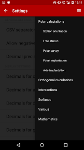
Polar calculations:
* station orientation
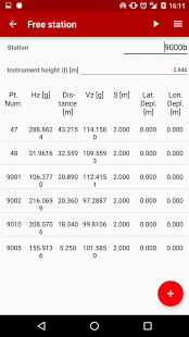
* free station
* polar survey
* polar implantation
* axis implantation
Orthogonal calculations:
* orthogonal survey
* orthogonal tracking
* orthogonal implantation
Intersections calculations:
* lines intersections
* circles intersections
* line / circle intersections
Surface calculations:
* surface included with arc of a circle
* parallel limit displacement regarding compulsory surface
Miscellaneous:
* field / distance
* point projection on a line
* circle computation using three points
* arc of a circle segmentation
Mathematics:
* triangle solver
* circular elements resolution
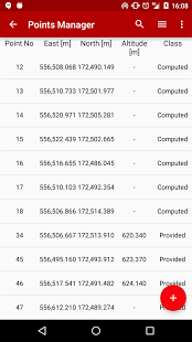
Data, such as points, can be imported into the application from CSV, LTOP or PTP
file formats and exported to CSV. The history of all the calculations, the
points and application settings can be exported to file (*.tpst) which can be
imported into other instances of the application or simply later on.
them determining new geographical points based on measurements and offering some
utilities. It is able to do the following calculations:
Polar calculations:
* station orientation
* free station
* polar survey
* polar implantation
* axis implantation
Orthogonal calculations:
* orthogonal survey
* orthogonal tracking
* orthogonal implantation
Intersections calculations:
* lines intersections
* circles intersections
* line / circle intersections
Surface calculations:
* surface included with arc of a circle
* parallel limit displacement regarding compulsory surface
Miscellaneous:
* field / distance
* point projection on a line
* circle computation using three points
* arc of a circle segmentation
Mathematics:
* triangle solver
* circular elements resolution
Data, such as points, can be imported into the application from CSV, LTOP or PTP
file formats and exported to CSV. The history of all the calculations, the
points and application settings can be exported to file (*.tpst) which can be
imported into other instances of the application or simply later on.