Transports Rennes
Transport info for France
Version: 4.1.3
Added: 26-06-2013
Updated: 04-10-2016
Added: 26-06-2013
Updated: 04-10-2016
Transports Rennes provides quick access to information about public
transportation of the city of Rennes, France and its sprawl. Information comes
from the open data initiative by Keolis Rennes, the company running Rennes’
public transportation system.
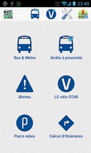
Features:
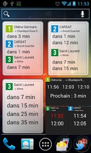
* Bus and metro schedule (widget available for even faster access)
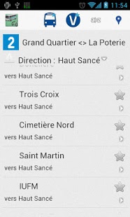
* Bus/metro itinerary computation
* Nearby bus stops and “LE vélo STAR” bikesharing stations
* Number of available bikes in “LE vélo STAR” stations
* Favorite bus stops, metro and bikesharing stations management
* Available parking space in park-and-ride facilities
* Disruption of service alerts and Twitter stream (@starbusmetro)
Google Maps are disabled in these builds. You can see the location of a
situation with a cartographic app such as https://f-droid.org/packages/com.robert.maps or
https://f-droid.org/packages/net.osmand.plus though. Proprietary libraries have been removed.
transportation of the city of Rennes, France and its sprawl. Information comes
from the open data initiative by Keolis Rennes, the company running Rennes’
public transportation system.
Features:
* Bus and metro schedule (widget available for even faster access)
* Bus/metro itinerary computation
* Nearby bus stops and “LE vélo STAR” bikesharing stations
* Number of available bikes in “LE vélo STAR” stations
* Favorite bus stops, metro and bikesharing stations management
* Available parking space in park-and-ride facilities
* Disruption of service alerts and Twitter stream (@starbusmetro)
Google Maps are disabled in these builds. You can see the location of a
situation with a cartographic app such as https://f-droid.org/packages/com.robert.maps or
https://f-droid.org/packages/net.osmand.plus though. Proprietary libraries have been removed.