WairToNow - Aviation Navigation
Aviation mappng program, includes geo-referenced airport diagrams and plates.
Version: 5.1
Added: 27-12-2020
Updated: 15-02-2021
Added: 27-12-2020
Updated: 15-02-2021
Open-source aviation mappng program, no-nonsense basics with minimum bells and
whistles. Includes geo-referenced airport diagrams and approach plates.
Source on https://github.com/mrieker/WairToNow
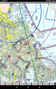
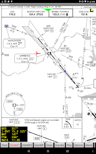
App covers areas covered by US charts, including sectionals, terminal area
charts, helicopter charts and what's left of world charts. Also included is
mapping via OpenStreetMaps for walking/biking to nearby $100 hamburger stands,
as well as georeferenced approach plates and airport diagrams. Also provides
OpenStreetMap-backed runway diagrams for all airports, though they are
primarily used for those airports that don't have official FAA-provided
airport diagram plates. Approach plates include an optional on-screen DME
display that the user can configure.

whistles. Includes geo-referenced airport diagrams and approach plates.
Source on https://github.com/mrieker/WairToNow
App covers areas covered by US charts, including sectionals, terminal area
charts, helicopter charts and what's left of world charts. Also included is
mapping via OpenStreetMaps for walking/biking to nearby $100 hamburger stands,
as well as georeferenced approach plates and airport diagrams. Also provides
OpenStreetMap-backed runway diagrams for all airports, though they are
primarily used for those airports that don't have official FAA-provided
airport diagram plates. Approach plates include an optional on-screen DME
display that the user can configure.